
As we embrace an era where technology seamlessly integrates into nearly every aspect of our lives, the world of maritime navigation is no different. The growing sophistication of smart navigation systems is reshaping how we perceive and ensure safety at sea. Imagine a world where every vessel, from modest fishing boats to colossal cargo ships, communicates and collaborates through a network of smart systems, transforming our perception of maritime travel. In this comprehensive guide, we delve into which state-of-the-art equipment best serves your maritime adventures, ensuring both safety and efficiency as you navigate the world’s waters.
Understanding the Essence of Smart Navigation Systems
smart navigation systems represent the convergence of technology and traditional maritime practices, crafted to enhance safety and operational efficiency. At their core, these systems are designed to gather, process, and display a myriad of data crucial for navigating the complex web of waterways.
Consider the Automatic Identification System (AIS), a revolutionary component of smart marine technology. It acts as a digital lighthouse, transmitting a vessel’s location, speed, and heading. In essence, AIS enables ships to “see” each other, even through dense fog or pitch-black nights, reducing collision risks dramatically.
Equally vital is the integration of real-time weather data, which helps mariners anticipate storms or adverse conditions long before they become a threat. Such foresight allows timely decisions, ensuring that ships and crews stay out of harm’s way.
Then there’s the burgeoning world of smart port technology, a crucial touchpoint for any vessel’s journey. These advanced systems facilitate seamless navigation in and out of busy ports, optimizing docking processes while minimizing delays and errors.
Together, these systems form an impressive network of maritime technology that is not just about moving from point A to B but doing so with unprecedented precision and safety.
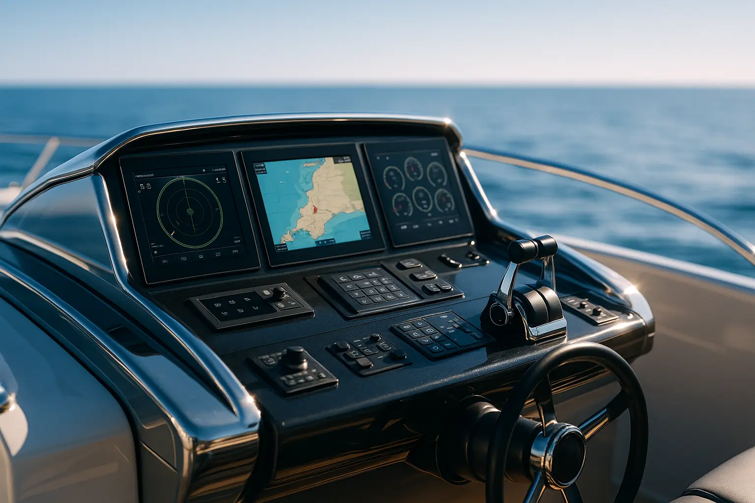
Crucial Equipment for Enhanced Safety at Sea
Selecting the right equipment forms the backbone of safe navigation. While each vessel’s needs may differ due to size and function, certain key technologies remain pivotal across the board.
The Electronic Chart Display and Information System (ECDIS) stands as a modern mariner’s indispensable tool. This digital navigation system provides critical charting information, seamlessly integrating with GPS to offer real-time location data. Unlike traditional paper maps, ECDIS updates dynamically, highlighting potential hazards and navigational challenges.
Additionally, radar systems have become more sophisticated, providing a 360-degree view of a vessel’s surroundings. These systems are particularly beneficial in congested waterways or during adverse weather conditions, where visual navigation is hampered.
For those venturing into open waters, the Global Maritime Distress and Safety System (GMDSS) is non-negotiable. This communication system is designed to ensure that mariners can send distress signals and receive vital safety information. Its global coverage ensures that help is never far away, even in the most isolated regions.
Lastly, integrating smart water sensors can provide instant alerts on water levels within the hull, preventing unnecessary accidents. Such preemptive measures safeguard vessels against flooding and balance-related mishaps, ensuring smooth sailing.
Leveraging Maritime Data: The New Age of Decision Making
In our digital age, the collection and analysis of maritime data have transitioned from being ancillary to indispensable in all maritime operations. Data-driven insights are now at the heart of every voyage, shaping decisions that impact safety, efficiency, and sustainability.
The role of AI and machine learning cannot be overstated in this context. These technologies sift through vast datasets, offering predictive insights that empower vessel operators to anticipate and address potential risks proactively. For instance, analyzing historical traffic patterns enables optimal route planning, reducing congestion and minimizing fuel consumption.
Furthermore, by integrating with satellite systems, ships can receive real-time updates on weather patterns, maritime traffic, and port conditions, allowing them to make informed decisions. Such dynamic navigation not only fosters safety but also enhances operational efficiency by reducing transit times and conserving resources.
In addition, the advent of big data in maritime systems facilitates fleet management. Fleet operators can monitor an entire fleet’s performance, fuel usage, and maintenance needs remotely, ensuring smooth operations and timely interventions when necessary.
Ultimately, the interconnection of these technologies has created a holistic navigational ecosystem where data is the true north guiding every decision.
Smart Systems for Small Vessels: Ensuring Safety for All Mariners
While the application of smart navigation systems is often associated with larger commercial ships, smaller vessels can equally benefit from adopting these technologies. Whether you’re a weekend sailor or a small-scale fisherman, integrating these systems can significantly enhance your maritime experience.
Portable AIS devices have become increasingly popular among small boat operators. These devices provide collision avoidance capabilities and allow for vessel tracking, ensuring that even the smallest boats remain visible in busy waters.
For navigation, compact handheld GPS units offer pinpoint accuracy, guiding mariners safely through uncharted waters. Coupling these with portable weather stations can further provide real-time updates on local weather conditions, enabling smaller vessels to avoid unexpected squalls or storms.
Moreover, smartphone apps have emerged as cost-effective solutions, offering a suite of navigational aids such as tide charts, meteorological data, and real-time maritime traffic updates. They bridge the gap for smaller vessels, ensuring that safety is not compromised due to budget constraints.
By embracing these technologies, even the most modest vessels can navigate with the same confidence and safety as their larger counterparts, democratizing access to smart marine technology.
As we cast off into the future, the adoption of smart navigation systems is not just an option but a necessity for ensuring safety and efficiency at sea. These advanced technologies, which include systems like AIS, ECDIS, and GMDSS, are revolutionizing how we perceive maritime navigation, offering a blend of safety and operational excellence.
Whether steering a small boat or overseeing a fleet of commercial vessels, the integration of smart systems is paramount. Not only do they reduce the risks associated with maritime travel, but they also foster a proactive approach to navigation, one that is informed by real-time data and cutting-edge technology.
In this new era, where technology and tradition intersect, embracing these advancements ensures that we can navigate the high seas with both confidence and peace of mind. As we continue to innovate and integrate, the horizon holds endless possibilities, promising a safer, smarter, and more connected maritime world.
FAQ
What are the primary functions of a smart navigation system for marine use?
Smart navigation systems for marine use primarily provide real-time location tracking, route optimization, environmental monitoring, and collision avoidance to ensure safe and efficient travel on water.
How does a smart navigation system differ from traditional navigation tools?
Unlike traditional navigation tools, smart systems integrate advanced technologies such as GPS, radar, sonar, and digital mapping to offer more precise navigation, automated route planning, and real-time updates.
What factors should be considered when choosing a smart navigation system for a marine vessel?
When selecting a navigation system, consider factors like system compatibility with existing equipment, ease of use, coverage area, accuracy, durability in harsh marine environments, and available support and updates.
Are there specific smart navigation systems recommended for small recreational boats?
For small recreational boats, systems like handheld GPS devices or smartphone apps with marine navigation features are recommended. They’re cost-effective, portable, and easy to use while providing essential navigation functions.
What safety features should be prioritized in a smart navigation system for sea travel?
Prioritize systems with features such as automatic distress signaling, collision alerts, weather updates, and man-overboard alarms to enhance safety during sea travel.